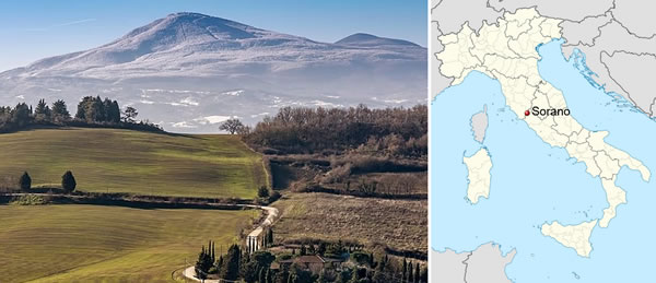
Mount Amiata and Sorano (Grosseto, Italy)

Mount Amiata derives its name from the Latin Mons Tuniatus-Montuniata, the land sacred to the Etruscans where their most important deity, Tinia (Jupiter to the Romans), resided, or from ad meata, meaning "at the springs"—thermal springs whose waters were considered miraculous.
The mountain is actually an ancient, extinct volcano, the second highest in Italy. Its last eruptions occurred between 305,000 and 231,000 years ago, contemporaneous with the period of activity of Roman volcanism. Its geological and magmatological nature is complex and heterogeneous, as it is situated, both spatially and temporally, at the boundary between the Tuscan and Roman Magmatic Provinces. Consequently, there is an interaction between two types of magma with different compositional and genetic natures at the source, giving rise to this volcano with a low-energy eruptive style. Furthermore, several uncertainties remain regarding the history of the intrusion of these magmas into the lithospheric crust. It is believed that the presence of a large, cooling magmatic pluton at a depth of 7-8 km is responsible for the high heat flow of the Amiata geothermal field. The final result of its eruptive activity constitutes stratigraphy of extremely variable thickness and consistency, ranging from the darkest pozzolanic sands to lithoid tuffs, and even flints.
A volcanic blanket covered the area straddling the border between Tuscany and Lazio, on the eastern side of the Fiora River, along the southern slopes of Mount Amiata, on the western side of the Paglia and Tiber rivers, up to the heights along the coastline. The erosive action of atmospheric agents intensely modified the ground surface, resulting in a more or less flat landscape, furrowed by rivers and streams that cut deeply into it.
The elongated rocky spurs, with narrow summit plateaus and steep vertical walls at the base of which flow streams—often fed by perennial springs—constituted a kind of designated place for all those who, from prehistory to the present day, needed to procure effective and quickly realizable shelter for a whole series of activities related to settlement. Thus, there are numerous artificial caves intended for residence, artisanal activities, agricultural annexes, etc., whose manifestations fall under the name of "rupestrian (rock-cut) civilization." It developed in a seismic territory among tuffaceous rocks with a high natural concentration of radon, volcanic-origin lakes, and thermal springs with hot water.
All centers located on the area of volcanic tuffs follow, among the various parts of the settlement, a distribution model that can be summarized as follows: at the summit are the built dwellings, whose foundations are partially excavated into the rock; on the flanks of the spur lies a series of artificial caves, often associated with terraced plateaus, presumably cultivated as gardens or fenced for courtyard livestock; and finally, on the gentler slopes, fortification works. The excavated part was chosen without regard for the consistency of the tuff layers, which could vary widely. The construction techniques appear more uniform, or rather, the traces left on the rock can be attributed to a limited set of tools. The main part is worked with a two-pointed pickaxe, although traces of other tools are not lacking.
On one of the most famous rocky spurs is Vitozza, an ancient abandoned settlement in the municipality of Sorano (Grosseto, Italy), 2 km from the village of San Quirico, on the border between Tuscany and Lazio. It is one of the largest rupestrian (rock-cut) agglomerations in central Italy.
The site is reachable on foot via a path of great charm and environmental value. It is structured on two levels, which, although partly connected and integrated, have different origins: the upper level pertains to medieval structures, while the lower level pertains to rupestrian architecture.
1 - Upper (or Medieval) Level: This is a flat tuff plateau, where there was certainly once a minor residential fabric, in some cases directly connected to the underlying rock-cut part. Today, only the remains of a church (called Chiesaccia) and two medieval fortresses are visible: one (also known as Roccaccia) had the function of controlling and defending the northwestern part of the tuff massif on which the medieval city of Vitozza stood, while the other controlled the southeastern part and the road leading to the upper part of the settlement. A path connects the three ruins and, descending, leads to the rock-cut area.
2 - Lower (or Rupestrian) Level (o rupestre): This is the area beneath the rocky height where over 200 caves and columbaria excavated into the tuff are located.
The columbaria (niches) were created in Roman times and housed the ashes of the deceased. From the Middle Ages onward, they were reused for raising doves and pigeons. Doves were raised for their meat and eggs, while homing pigeons were the fastest means of communication available, thanks to their ability to find their way back to the nest.
From the earliest times, the hypogeal (underground) spaces were used as dwellings. Based on their use, the caves have been divided into three types:
• Caves for mixed use (as a dwelling and stable): in this case, the shelters for animals were on a different (lower) level than the dwelling, or in some cases on the same level but in separate areas.
• Stables (recognizable by the presence of mangers, troughs, and enclosures).
• Caves for habitation (found especially on the more sheltered and sun-exposed southwest slope). These latter were inhabited until the end of the 18th century. Today abandoned, they still bear traces of their use, such as grain storage jars (ziri), cisterns for collecting rainwater, waste pits (pozzi da butto), niches, holes, and curbs for positioning beds (giacigli) and mortar bases (pestarole).
In the past, the caves likely had small walls—of which almost no trace remains today—that separated the interior from the exterior environment and featured a door. In inhabited caves, remains of fireplaces, flues, niches, shelves, and other elements used by the inhabitants are recognizable, while in those reserved for animals, mangers, niches for sheltering the young, and other equipment for animals can be identified.
The excavation of rock-cut environments for habitation purposes initially occurred during the Final Bronze Age, approximately between the 12th and 10th centuries BC, and subsequently in the Middle Ages, from late antiquity/early Middle Ages up to the central centuries, i.e., until the 12th century or shortly beyond.
Between these two periods, there are, of course, examples of reuse or new excavation of hypogeal spaces, but their purpose is, or seems to be, in the vast majority of cases, different from residential. These include the series of rock-cut tombs, from the simplest to monumental architectural ones, characteristic of the Etruscan period, or the Roman columbaria, later reused as places for raising pigeons.
Even after the medieval period, people continued to live in caves, but the number of new excavations decreased, though they are still regularly mentioned in communal statutes in 1556, up to the current use as cellars, agricultural sheds, and garages.
The most evident aspect of this abandoned settlement is the mixture between "negative" and "positive" architectures: that is, the gradual and almost natural transition established between the artificially excavated caves on the tuff walls and the dwellings above. Often built with the same tuff excavated from the caves, the inhabitants used as a roofing material the most tangible sign of human work, as bricks had to be imported from nearby centers due to the lack of clay deposits in the immediate vicinity.
Vitozza was part of that large county that the Aldobrandeschi family was forming starting from the 8th century, through exchanges and annexations, throughout present-day southern Tuscany. At the end of the 11th century, the medieval city arose around the castle of the Aldobrandeschi family. At that time, Vitozza must have been part of a large fief that included 15 castles, among which are remembered Sorano, Pitigliano, Farnese, Mezzano, etc. (Terra Guiniccesca.) The fief must have had considerable strategic importance since, thanks to the fortifications, it was possible to control the natural access routes to the sea. The castle structure was built above a rock-cut settlement very likely inhabited already in Etruscan-Roman times.
In the second half of the 12th century, the construction of the city walls began, and the first documentary evidence testifying to the presence of a castle, recently acquired by the Aldobrandeschi family, dates back to the early 13th century.
From the beginning of the 13th century, the Aldobrandeschi county, already eroded by the expansion of the territories of the surrounding municipalities, underwent further subdivision among the various members of the family. In one of these acts of division, Vitozza was included in the southern zone of the county, together with the present-day centers of Sovana, Pitigliano, Piancastagnaio, Castellazzara, Montorio, Selvena, Sorano (in Tuscany) and Ischia, Farnese (in Lazio). The same act also agreed upon place names of currently abandoned locations like Morrano and Castro and others more difficult to identify.
During the 13th century, Vitozza must have played a rather important role in settlement events around Sorano. After Sovana, the episcopal seat, and Pitigliano, the comital seat, Vitozza was the most important center, considering the volume of tithes that the parish church (pieve) and the other two existing churches managed to collect.
In the same years, coinciding with the weakening of the feudal power of the Aldobrandeschi, the expansionist policy of the municipality of Orvieto was implemented, which, until 1334, exercised fairly strict control over the settlement's affairs. A lordship, that of the Baschi—perhaps connected to the Terra Guiniccesca and related to the Aldobrandeschi since the end of the 13th century—also nominally extended to Vitozza.
From the 14th century, the information we have outlines an extremely precarious local situation, with contraction and abandonment of numerous inhabited centers, which continued to deteriorate in the following century with the struggles waged by the Orsini (the male line of the Aldobrandeschi dynasty died out in 1302, and a branch of the Orsini family succeeded to the leadership of the county) against the Sienese. This led to a new reduction of the county's borders, now probably limited to the current municipal territories of Pitigliano and part of Sorano, lacking the center of Sovana (which became Sienese after 1413), and of Castell'Ottieri, Montorio, and San Giovanni, belonging to another lordship.
The peace agreement of 1455 concluded the hostilities between Siena and the Orsini and sanctioned Siena's loss of Vitozza.
The settlement, now in crisis and becoming difficult to defend, was gradually abandoned, and the administrative center of the area was moved to San Quirico.
Despite the limitation of territorial borders, the construction of two enormous fortresses was undertaken around the mid-16th century, one in Sorano and one in Pitigliano, with a role of psychological deterrent against potential attackers. By then, however, feudal power was exercised over an extremely impoverished county, so that between 1604 and 1608, the Orsini sold the entire territory to the Medici. A personal fief of the Medici was thus created, with a stagnation of all economic and settlement activity (masterfully described in a 1723 report) that would only change with the intervention of the House of Lorraine. The medieval city began its decline, while the caves, more easily restorable, were inhabited at least until 1783, especially those located near San Quirico; one of these, locally known as the "saltpeter cave" (grotta della salnitraria), around 1766 was probably used for the production of saltpeter.
Saltpeter, commonly known as potassium nitrate, was used as fertilizer by the ancient Greeks or as a cleanser by the Romans. Pliny mentions saltpeter as the element at the origin of the discovery of glass.
It is indeed narrated that a Phoenician ship of saltpeter merchants landed on a beach where they set about preparing their dinner. Not finding stones on which to place their pots, they used blocks of saltpeter which, under the effect of the heat from the flame and mixing with the sand of the beach, gave rise to shiny rivulets of an unknown liquid clearly identifiable as glass.
- Pliny the Elder, Naturalis historia (Book XXXVI, verse 65)
Mount Amiata and Sorano (Grosseto, Italy)
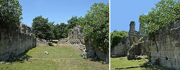
Chiesaccia seen from the inside and outside - Vitozza, Sorano (Grosseto, Italy)
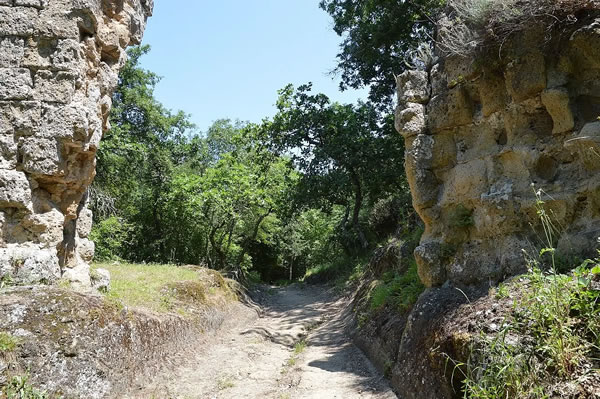
An entrance to the first castle of Vitozza - Vitozza, Sorano (Grosseto, Italy)
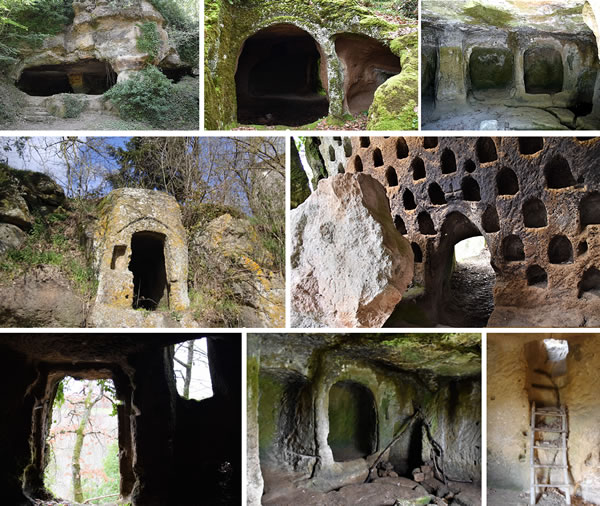
Entrance and interior of some caves, and the columbaria. - Vitozza, Sorano (Grosseto, Italy)
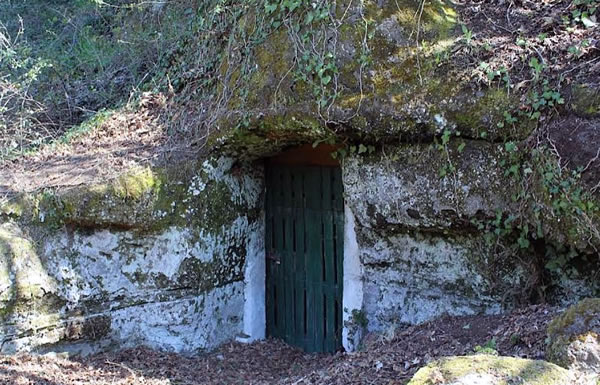
Reuse and closure with a door of a hypogeal space today - Vitozza, Sorano (Grosseto, Italy)
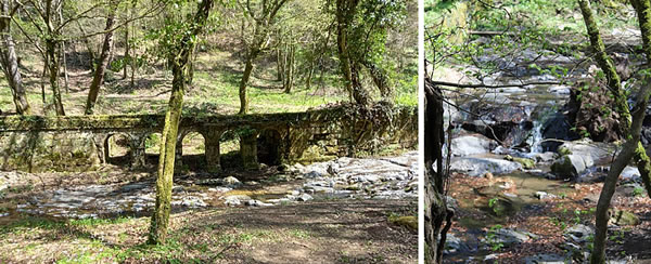
Section of the 19th-century aqueduct and the Lente River - Vitozza, Sorano (Grosseto, Italy)
This page was last edited on 14 March 2026
© andmorestory.eu - All right reserved